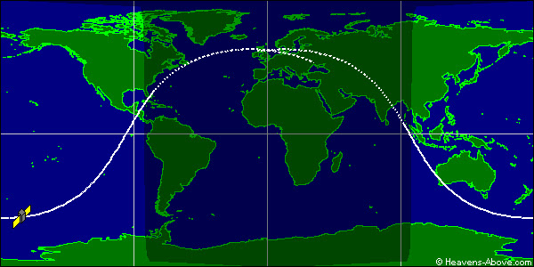
Here's the latest map projecting the landing. Estimated reentry time: 1210a CDT on 24 September ± 2 hours.
ORIGINAL POST:
Tonight the UARS satellite comes crashing back down to earth. As of late afternoon on 23 September, it is projected to come down around 1100p ± 3 hours. The Center for Orbital Reentry and Debris Studies keeps abreast of the latest projections for where the satellite will reenter the atmosphere.
Each tick mark represents a five-minute increment. The entire four-orbit run shown above, represents the three-hour uncertainty period. This uncertainty period has changed and shifted as more data becomes available. Last night's projections had it coming down just west of South America around 800p CDT with a 12-hour uncertainty period. (And, therefore, last night on their site there were many more orbits shown.)
However since then it has slowed more than predicted. Changing its reentry time and the likely place of reentry to the areas shown above.
The debris field may be up to 500 miles long, with some two dozen or more pieces big enough to survive reentry and hit the Earth. Areas near the point of reentry should be treated to quite the light show.
At 630p CDT, it's over the South Pacific Ocean, beginning its curve northward toward Central America and Florida. (See real-time images here.)
But what we really love is artist's renderings and graphical representations. Here's a youtube video from a firm called AGI that shows how all this might take place:
Finally, you all should know a little bit about the satellite itself:
UARS (Upper Atmosphere Research Satellite) was launched in 1991 to better understand chemical constituents of the atmosphere and atmospheric photochemistry and transportation. One of its first studies was how Mount Pinatubo's eruption carried its sulfuric acid and other volcanic gases throughout the atmosphere.
From NASA's UARS Science page:
The satellite was launched in 1991 by the Space Shuttle Discovery. It is 35 feet long, 15 feet in diameter, weighs 13,000 pounds, and carries 10 instruments. UARS orbits at an altitude of 375 miles with an orbital inclination of 57 degrees. Designed to operate for three years, six of its ten instruments are still functioning. UARS measures ozone and chemical compounds found in the ozone layer which affect ozone chemistry and processes. UARS also measures winds and temperatures in the stratosphere as well as the energy input from the Sun. Together, these help define the role of the upper atmosphere in climate and climate variability.
Since some of its final orbits pass over North America, it's worth keeping an eye on the latest updates to see if you can watch the debris pass overhead.


